Texas Shark Rodeo requires GPS coordinates of your catch location to qualify for submission.
A precise catch location is vitally important in the gathering of research data for scientific reasons.
TSR will not release any catch location data that you submit to the public, it is given to HRI & Guy Harvey Research Institute when tag or fin clip information is passed along to them.
We have instructed both HRI and GHRI to not release the location information to the public or by request from any private individuals to protect your fishing spots.
Please read below for ideas of using devices you may already own as a source of GPS Coordinates needed for catch submission.
There are two formats of GPS coordinates that TSR will accept at this time.
1. Decimal Degrees "DD" format. Example Latitude: 27.613736 & Longitude -97.201512
2. Degrees Minutes Seconds "DMS" format. Example: Latitude 27°36'49.5"N & Longitude 97°12'05.4"W
GPS coordinates can of course easily be obtained from handheld GPS devices, and also GPS navigation devices built into vehicles.
Smartphones can also obtain GPS coordinates via apps that may either be built in or downloaded from whatever store the phone uses.
Some apps cost money but there are a lot of them for free, check to see that it will give you a GPS position and try them out.
A good link on iPhone GPS signal usage is below
How to use the iPhone as a GPS mapping device
There are simply too many smartphone models out there for us to try and research each one in advance, please use the following information to help you research the capabilities of your particular model phone.
To investigate whether or not your smartphone has a dedicated GPS radio that can function without a cellular connection try to do a search with the following keywords.
(Your Model Phone) gps position without cellular signal
If results do not show try different variations of the keywords relating to GPS and no cell signal to find out information for your particular device.
Other key words to try along with your model phone are GPS backcountry, GPS hiking, GPS backpacking, GPS without wifi.
Eventually you should find out information regarding the GPS radio and it's ability to work without wifi or cellular signal.
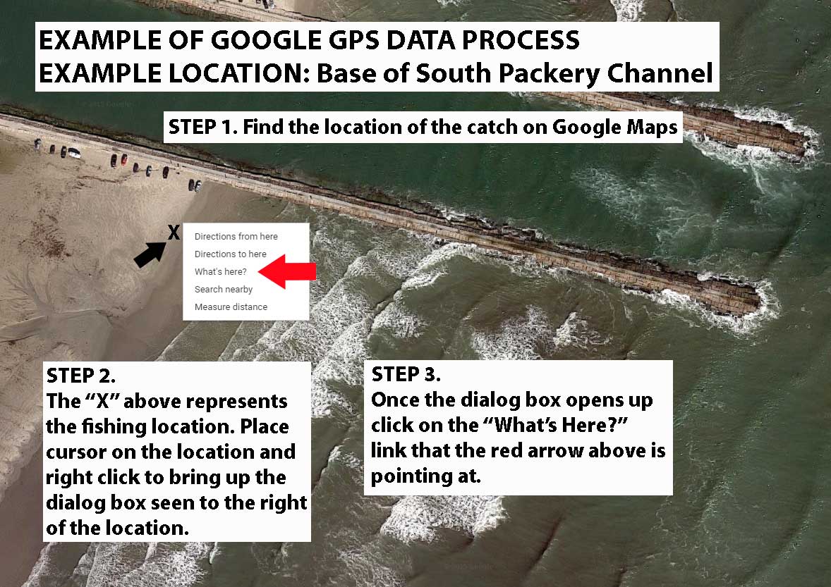
Another technique to find GPS coordinates for your location you fished is if you can pinpoint it on a satellite view of Google Maps.
Instructions and examples on how to get GPS coordinates from Google maps.
The location chosen as an example is the beach right next to the South Packery channel jetties in Corpus Christi.
1. Find your catch location on Google maps (Link to Google maps will be below these instructions).
2. Place cursor on location and right click which will bring up a dialog box as shown below in the example photo.
3. Click on the "What's Here?" option in the dialog box as shown below in the example photo.
Below is a sample of the information box that will pop up in the upper left corner of the map once ''What's Here?" has been clicked.

Copy down the DD format (Decimal Degrees) GPS coordinates given.
Latitude is given as the first number and Longitude is given as the second number in the example.
The example location has the GPS coordinates of Latitude 27.613804 & Longitude -97.201429 in Degree Decimal "DD" format.
These Latitude and Longitude coordinates would then be entered into the form during the catch submission process.